La Guida Turistica del Pianeta Terra: un'esilarante avventura dalla Namibia alla Liguria!

La Guida Turistica del Pianeta Terra: un'esilarante avventura dalla Namibia alla Liguria!
La Guida Turistica del Pianeta Terra: un'esilarante avventura dalla Namibia alla Liguria!


On this page we write about two nearby and equally panoramic mountains of the Ligurian Apennines: Monte Pccile and Monte Zatta; These are comfortable and fascinating paths both with snow and without, with beautiful views of the sea and the hinterland.
Both peaks can be climbed starting from the pace of the biscia, reachable by car in just 40 minutes from the motorway exit of blackboard. For Monte Zatta, however, it is more comfortable starting from the Bocca Pass, also just 45 minutes from Chiavari and blackboard.

To reach the piglet you park at the pace of the biscia, at a fairly broad slargo, where there is also a small church. From here he starts walking along a dirt road, overcoming a bar. We proceed in falsopiano in a beautiful wood, you will soon earn beautiful views of the pyramid of Monte Pccile.


On top, the view is amazing !! The name pigsty certainly does not make the beauty of the place. You can admire the Ligurian Apennines east, up to Tuscany.


The descent takes place on the same itinerary, along the northern face of the piglet, for those who also want skiing! In all, from the pace of the biscia to the piglet tops are 5 kilometers of walking, and as many for the return: keep account of at least 3-4 hours for the excursion, more when it sinks into the snow (which anyway is a fairly enough event Rare).

For a shorter route, you can start from the Passo del Bocco, where you park at about 1000 meters of altitude at a slarg in front of the bush pond. This is the northern slope, more shady, but also where it is more likely to find snow in winter.


Here you divert to the right, and walking in part in the crest and partly among the trees immediately below, you arrive at the central zatta and then to the eastern zatta. The views are exceptional, even on the Ligurian Sea: the Portofino promontory is noted.


When there is no snow, the winter landscape is sad, but in spring and summer, With the green of leaves and meadows, or even at the beginning of autumn, with the Foliage, this itinerary is still very pleasant. In short, with or without snow, visit Zatta, Porcile and all the Ligurian Apennines, which always gives joys.
good trips !!
If you like outdoor activities and adventurous trips or If you want to find more photos of this and other destinations, as well as advice and new itineraries, visit our FB page and put it like:
Share this page with your friends:

Have you put it on our FB page?
Click here For an overview of the trekking in Italy
.JPG)
You will also find the links to the descriptions of several interesting hiking itineraries, including other snowshoeing and all the paths of Liguria (on the snow for example the Monte saccarello e Faallo and Monte Reixa Sopra Genova.
trekking in Liguria

Here is another fantastic way to see Liguria:
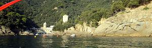
Liguria in KAYAK - Photos and Itineraries
Some Trekking Theme Diary, full of ideas and photos:
.JPG)
Crete - Photos and travel routes
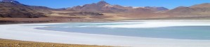
Chile and Patagonia Argentina
we go away, in authentic hiking paradises, with itineraries from deserts to glaciers
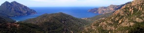
Corsica - Photos and travel itinerary
a wild island at your fingertips, ideal for hiking itineraries, with crystal clear sea and steep mountains
.JPG)
Iceland
Discover Here The tourist guide of the Planet Earth , the richest, exciting and ironic guide on the whole world.
contact info@wildrips.net Click on a route, suggestions on a travel diary, collaborations or to organize trips at sea in Liguria.
Site map - Privacy