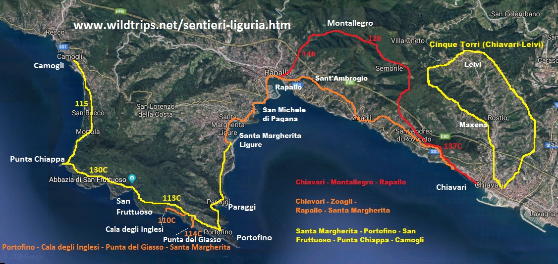
The hiking itinerary from Chiavari to Zoagli is a stretch of the Liguria path not very popular. Yet the reasons of interest is not lacking!
The first part of the route coincides with what from Chiavari leads to Montallegro and, in particular, with the path of the Thanks/Ring of Monte Telegraph, already described in the Page on the path to Montallegro . However, we report this information here, then detailed how to walk to Zoagli. (Walking is one of the two best ways to appreciate the stretch of coast between Chiavari and Zoagli. The other is the Canoe, itinerary described here !)
From Chiavari, there are two main access points to walk to Zoagli, avoiding the road. The most beautiful, even if the beginning doesn't seem promising, it is at the end of the sea walk of Chiavari, a west side. Following the way along the sea, in fact, the railway is drawn and a hit anonymous path is part. (Alternatively, you can start from a staircase close to the exit of the Chiavari motorway: even in this case, a little panoramic start door quickly to splendid views).
Using the path that part of the sea side, goes up in about twenty minutes to the sanctuary of the Grazie, which offers a splendid view of the Gulf of Tigullio and Portofino. Looking at the sanctuary, on his right there are, usually some tables resting. From here a steep path is in the woods, quickly reaching the most panoramic stone houses. (Alternatively you can continue 100 meters along the Aurelia and then go to the woods, but this standard solution of the Liguria path is in my opinion less panoramic).
This is the hill of the graces, which stands on the western part of Chiavari, and the paths on it are part of the ring of Mount Telegraph. From the trail of the graces the excursion continues to Zoagli continued walking towards the west towards Mount Telegraph. The itinerary in the woods is well marked, until you arrive among the olive groves, just before Sant'Andrea di Rovereto.
Once the olive groves have passed, you are at a crossroads where, continuing straight, you go to Montallegro (which is signed at 3 hours later), while going down to the left, on a very busy paved road, you head towards a neighbor Campanile and a set of houses: it is precisely from Sant'Andrea di Rovereto. Alternatively, you can continue to Montallegro, overtake Sant'Andrea behind and then get off at San Pietro di Rovereto with a Creza between the terraces. Both solutions are nice and suitable for walking from Chiavari to Zoagli, although the second is slightly longer and tiring.
If you have opted to continue on the paved road towards Sant'Andrea in Rovereto, you can enjoy this beautiful view of the church of Sant'Andrea with behind the village of San Pietro di Rovereto on the crest of the hill, and Santa Margherita Ligure in the background.
Sant'Andrea and San Pietro di Rovereto are the two main villages that meet in the hiking itinerary between Chiavari and Zoagli. From San Pietro also passes the Ring trail of the five bell towers and from here you can also easily connect to the path of the five towers between Chiavari and leivi . San Pietro is also splendid for its location.
From the Church of St. Peter, there are clear directions to continue towards Zoagli. In fact, it takes a path that descends towards Aurelia (the alternative is to continue along the beautiful path of the 5 bell towers, towards Semorile).
Aurelia is the main road (and in fact the only one) that connects Chiavari and Zoagli, and you reach it shortly after having seen the castle of Sem Benelli.
Cross the Aurelia, after a few meters a sign of the Zoagli station. It follows, but by taking the pedestrian Via Mameli instead of the paved road. Walking among the houses, you will soon get to the beach of Zoagli.
The journey time for this beautiful excursion between Chiavari and Zoagli just exceeds two hours, plus any pauses and deviations. From here you can continue on foot to Rapallo, or return to Chiavari by train.
This itinerary is one of the many trails between Genoa and Tuscany, all paths and all described to this Page on Trekking in Liguria . To travel the entire west riviera to the east, the previous stage is that Between Santa Margherita, Rapallo and Zoagli , while the next route door from Chiavari in Lavagna and Sestri Levante . Good trip!
If you like outdoor activities and adventurous trips or if you want to find more photos of this and other destinations, as well as advice and new itineraries, visit our FB page and put like:
Share this page with your friends:
Have you put it on our FB page?
Click here For an overview of the trekking in Italy
You will also find links to the descriptions of several interesting hiking itineraries, for example a portofino , trekking between The Cinque Terre and Portovenere e The very comfortable but no less beautiful Excursion to Sestri Levante and Punta Manara .
Here's another fantastic way to see Liguria:
Liguria in KAYAK - Photos and Itineraries
click here instead for the page specifically dedicated to trekking in Liguria
or, excite yourself for Italian beauties from a sailboat.
Italy in Vela - Photos and travel itineraries
from North to South, 800 miles of navigation between spectacular islands, picturesque towns and memorable wines
some trekking theme travel diary, full of ideas and photos:
Corsica - Photos and travel itinerary
a wild island at your fingertips, ideal for hiking itineraries, with crystal clear sea and steep mountains
Iceland
Crete - Photos and travel routes
Chile and Patagonia Argentina
we go away, in authentic hiking paradises, with itineraries from deserts to glaciers
Discover Here The tourist guide of the Planet Earth , the richest, exciting and ironic guide on the whole world.
contact info@wildrips.net Click on a route, suggestions on a travel diary, collaborations or to organize trips at sea in Liguria.
Site map - Privacy