La Guida Turistica del Pianeta Terra: un'esilarante avventura dalla Namibia alla Liguria!

La Guida Turistica del Pianeta Terra: un'esilarante avventura dalla Namibia alla Liguria!
La Guida Turistica del Pianeta Terra: un'esilarante avventura dalla Namibia alla Liguria!


The highest mountains of the Ligurian Apennines are located around Santo Stefano d'Aveto; The beautiful landscapes of this area are crossed by different paths that really become fabiliaries when the snow whitewall peaks. On this page we suggest some beautiful routes with snowshoes (but obviously recommended also as normal walks) towards Mount Black, the Maggiarasca, the Monte Bue and Mount Aiona, also passing through the onion lawn, Lake Lame and the lake Black.


If you proceed for Lake Nero (we will describe later how to arrive at Bue and Maggiarasca, and at the end we will have a synthesis of different paths), you have to walk on the coast, passing around Monte Bue, in typically increasingly snowy areas being turned to North.

Above Lake Black stands imperious. The Monte Nero, 1754 meters high. To reach the summit you have to walk towards Monte Bue, except to deviate and follow the path on the crest of Monte Nero, not always very comfortable with snowshoes. The views repay fatigue.


After admiring the black lake from above, as well as the expanse of the mountains of the Ligurian Apennines and the Vette del Monte Bue (with the arrival of the chairlift) and of the increasing (with antennas on the top), you can go back or head to the latter. Obviously, it is advisable to divide these itineraries into at least two different hikes with snowshoes, although the complete ring route starting from Rocca d'Aveto in theory would be feasible - but really excessive.
Once you get out of the crest of Monte Nero and returned to the itinerary for Monte Bue, you go back to snow slopes towards the top of this mountain.

From Monte Bue, following one of the ski slope (generally the red, the steeper and therefore rapid) yes You can get to the onion meadow or, alternatively, deviate early towards the Mosto Maggiarasca.


In summary, I would say that a very interesting ring for an intense day trip is: Rocca d'Aveto - Lago Nero - Monte Bue - Prato della Cipolla - Rocca d'Aveto. A second ring that deserves, a little shorter, is that Rocca d'Aveto - Rocca del Prete - Maggiarasca - Meadow of the onion - Rocca d'Aveto. You can add the Black Monte to the first ring, or, with more calm, go up from Rocca d'Aveto to the onion and then to Monte Nero and go back for the same path - and maybe uphill you can also use the chairlift.
a Other route with interesting snowshoes in Val d'Aveto area is the one at Mount Aiona from Lake Lame.


I hope all these suggested itineraries are useful for planning your trips. So many paths cross on this part of the Ligurian Apennines and the Council is to take advantage of it! Especially with snow when the landscapes become really high mountain. Given the proximity of the sea and the quotas, in winter the snow is not always guaranteed, but you can control the situation on the webcams of the Val d'Aveto plants. Good snows!
If you like outdoor activities and adventurous trips or if you want to find other photos of this and other destinations, as well as advice and new routes, visit our FB page and put like:
Share this page with your friends:

Have you put it on our FB page?
Click here For an overview of the trekking in Italy
.JPG)
You will also find links to the descriptions of several interesting hiking itineraries, including other snowshoeing and all the paths of Liguria (on the snow the neighbors Zatta and Pccile , but also the wonderful Monte saccarello and, behind Genoa, Faiaro and Monte Reixa .
trekking in Liguria

Here is another fantastic way to see Liguria:
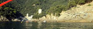
Liguria in KAYAK - Photos and Itineraries
Some Trekking Theme Diary, full of ideas and photos:
.JPG)
Crete - Photos and travel routes
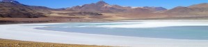
Chile and Patagonia Argentina
we go away, in authentic hiking paradises, with itineraries from deserts to glaciers
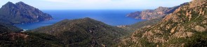
Corsica - Photos and travel itinerary
a wild island at your fingertips, ideal for hiking itineraries, with crystal clear sea and steep mountains
.JPG)
Iceland
Discover Here The tourist guide of the Planet Earth , the richest, exciting and ironic guide on the whole world.
contact info@wildrips.net Click on a route, suggestions on a travel diary, collaborations or to organize trips at sea in Liguria.
Site map - Privacy