La Guida Turistica del Pianeta Terra: un'esilarante avventura dalla Namibia alla Liguria!

La Guida Turistica del Pianeta Terra: un'esilarante avventura dalla Namibia alla Liguria!
La Guida Turistica del Pianeta Terra: un'esilarante avventura dalla Namibia alla Liguria!


We described Here all the beauties of Dominica , the wilder caribbean island, but The famous path to Boiling Lake, the boiling lake in the middle of the tropical forest, deserves a page to itself. Many hiking lovers visit Dominica only for this itinerary in the great nature of the island. On this page you will find the information to take the trek to Boiling Lake with or without a guide ... because yes, although everywhere there is written that a guide is necessary, with due preparation this path is also passable independently.

First of all, the start of the Boiling Lake path can be conveniently reached by car following the signs for the Gorge tituent. The winding roads of Dominica and road signs are definitely not the maximum, but an offline navigator will help you make the company. Indeed, the offline Maps.me navigation app also has the GPS track of the Boiling Lake path (with some imprecise): this is a first source of information very useful (but not enough) for those who want to travel the itinerary without a guide.

From the beautiful tituo Gorge, the beginning of Boiling Lake Trail is evident and reported by a sign. The first part of the route is all in the tropical forest. Practically impossible to get lost here, very likely, instead, mute! He stops to have breakfast here. On average, you arrive at the Breakfast River after an hour from departure.
Crossing the stream, you need to look for the path that goes up to Mount Morne Nicholls. It is quite simple to find it, because the path of the route remains evident, but it is also fundamental not to make mistakes. To this end, having a GPS track on the mobile phone is useful for no doubt. However, precisely, continue only if you are on a clear path.
goes up among the vegetation, this time on a steepest route, up to a muddy crest. Here it is good to slip down, because the fall would be ruinous. It is sufficient to walk carefully. The trek for Boiling Lake proceeds to the panoramic top of Mount Morne Nicholls, from which you see, in the distance, even some Roseau's house (the capital of Dominica) and the Caribbean Sea.

Going down from Mount Morne Nicholls, the environment starts to change. In addition to tropical vegetation, in fact, they initiate to see the typical colors of volcanic landscapes and, in the distance, clouds of smoke that rise from the ground, including - one can already imagine - the steam produced by Boiling Lake.
The descent on the path becomes more steeper but always evident (and also very muddy) until you get to glimpse the desolation valley. Here the landscape is undoubtedly volcanic, the red, yellow and white soil, with the air that starts knowing about sulfur. It slips down to a throat, also helped by a rope, and you arrive precisely in the Desolation Valley, walking between sulphurous fumarole and small pools of boiling water.

I was in solitary and perhaps I was right to wait for a guided group (I had met in the desolation valley an intent guide to boil eggs in a pool of water sulphurea - I can't say how they came!), But in the end I opted for Follow the stream. Arriving at a strangely difficult passage, I came back a little further backwards, finding a path that takes up in the woods to the bottom. This path goes into the vegetation, then returns to the stream again (with a rope that helps overcome a difficult passage) and gives it in front of a beautiful natural puddle.

From the puddle in the photo above the last stretch of path (here well traced) towards Boiling Lake. First we proceed immersed in tropical vegetation, then you arrive at another fumarole wedge valley. Having the GPS track is useful, but even here you need to invent the path. It rises between red and yellow and white stones, in the middle of green mountains, and closer closer to the cloud of steam that rises from Boiling Lake.


In short, you can do or not this wild path in the interior of dominica without a place companion? The answer is yes, with some accotes. Having the GPS track is the first. Be sure to presence of other groups along the route is the second, and it is particularly important, even more so if, like me, you are just solo. Third useful suggestion is not to go alone, because if something happens no one will call aid (and here I was disobedient). Being in good physical fitness, with a certain sense of orientation and excellent balance is fundamental, because some points are slippery, steep, at risk fallen, and while a guide can perhaps show you an easier route, if you are alone you have to get caught.
As for the clothing, keep in mind that you will get dirty and you will be went (the temperatures between 22 and 27 degrees will mitigate the latter problem). A k-way and waterproof trekking shoes could be useful.
Finally: Is it really worth doing all this effort to reach Boiling Lake? Of course!! Not so much for the goal, but for the path itself, which gives great satisfaction, allows you to admire the amazing landscapes of Dominica and makes you immerse in a wonderful adventure ... which, without a guide, becomes even more exciting.
If you like wild trips or if you want to find more photos of this and other destinations, as well as advice and new routes, visit our FB page and put like:
Share this page with your friends:

Have you put it on our FB page?
Visit the pages dedicated in general to Itineraries in the Caribbean , and then going to discover, besides Dominica , even Martinique , Guadeloupe , Saint Lucia and the other beautiful islands of This part of the world.
You will also like these diaries:
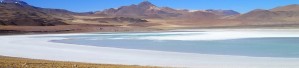
Chile and Patagonia: Travel and photo itinerary
in a amazing nature, 8000 km from deserts to glaciers passing for high colored mountains 6000 meters
El Salvador: Travel and Photo Itinerary
Climbing of Volcanoes, Diving in Lakes and Waterfalls, Relax on the Pacific and Tanta Allegria
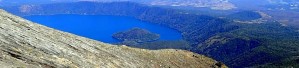
Guatemala: Travel and photo itinerary
The beautiful Antigua, Lake Atitlan, active volcanoes and lots of jungle
.JPG)
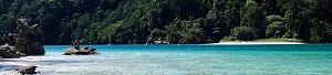
Panama: Travel and photo itinerary
Islands in the Caribbean Sea, beaches on the peaceful bank, and a pile of jungle in the middle

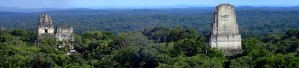
Belize: Travel and photo itinerary
.JPG)
Italy in Vela - Photos and travel routes
Italy by boat in Vela, from north to south, 800 miles of navigation between spectacular islands, picturesque towns and wines memorable
.JPG)
Brazil: photo and travel itinerary
Rio The Janeiro, Iguacu waterfalls, tropical islands and other wonders
Chile and Patagonia: Travel and photo itinerary
in a amazing nature, 8000 km from deserts to glaciers passing for high colored mountains 6000 meters
Thailand and Laos: travel diary and photos
a journey rich in sensations: sun and beaches, jungle and rivers, bangkok and traditional villages
.JPG)
United States: Travel and photo itinerary
5000 km through California and the great parks: lots of freedom and even more attractions
Discover Here The tourist guide of the Planet Earth , the richer, exciting and ironic guide on the whole world.
contact info@wildrips.net Click on a route, suggestions on a travel diary, collaborations or to organize trips at sea in Liguria.
Site map - Privacy