Travel itineraries, hiking, kayaking and sailing in Italy and in the world
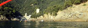
Sori is a small town on the Ligurian Riviera, in a splendid position between Genoa and the promontory of Portofino, from which some beautiful paths leave. Towards Recco, the most spectacular destinations are Sant'Apollinare and the statue of the Redeemer, while towards Bogliasco the most panoramic destination is Monte Santa Croce. Well, these goals can be reached on different trips, or connected with a single sensational 17 km ring itinerary. Sori beach, beautiful starting and arrival point of the itinerary
We describe in this page all this path that passes on the ridges of the hills of Sori, but if 17 km (and 800 meters of height difference) you will scare you, you can divide the trip to various excursions: one towards Sant'Apollinare, the cave of Camascenza, the Statue of the Redeemer and Mount Castelletto; another towards Mount Santa Croce; And another still, wanting, towards Case Cornua, the Monte dell'Uncellato and the meadows along the Provincial Road of Monte Bande. The path between Sori and Sant'Apollinare
We then start from Sori, whose small and graceful village overlooks a beautiful beach, from here, we go up towards Sant'Apollinare on a steep staircase that starts from the Aurelia road, at a small church. This first part of the path coincides with a part of the hiking itinerary between Recco, Bogliasco and Nervi .
The staircase passes between houses and olive groves up to the church of Sant'Apollinare, a splendid panoramic balcony on the Gulf Paradise. We are about 240 meters of altitude and you can admire Genoa and a part of the promontory of Portofino (Punta Chiappa in particular). The church of Sant'Apollinare and its panorama
A few meters before arriving in Sant'Apollinare, a path on the left leads to a source, but the interesting thing (at least for the most intrepid) is that from this path there is the possibility of going down to the forest to the geographical point with latitude 44.372754 and Longitude 9.116009 (Use Maps), where there is the cave of Camascenza. There is no beaten path, but there are few hundred meters (in which, however, there is a risk of slipping or ending up in the brambles). The cave cave is 18 meters long, partly flooded, with a masonry entrance because it was a refuge in the Second World War. A place from Indiana Jones (itinerary not recommended to those who are not agile, to those who have children or anyway to those who want to be prudent!). The cave cave
Leaving the cave of Camascenza returns to Sant'Apollinare and from here it takes up to rise to the statue of the Redeemer (the signs also indicate Case Cornua). This statue at over 400 meters of altitude is on a highly panoramic ridge, with sublime views of the promontory of Portofino as well as on Genoa. Panorama towards Genoa from the path between Sori and the statue of the Redeemer
To get to the statue of the Redeemer by Sori (deviation to the cave of Cambascenza excluded) it is necessary to walk for just over 1 hour, but a fairly tiring hour because in steep climb. After the statue of the Redeemer the path proceeds more in falsopiano towards Mount Castelletto; Then, admiring other very wide views over the whole Paradise Gulf, go up to Mount Cassinea. The panoramic trail in the ridge, above the statue of the Redeemer
Here we have nowhere in the hills, at 600 meters of altitude, and there are beautiful panoramic meadows to make picnic. Proceed on the path to the Provincial Road of Monte Bande, which passes through the overview of the Alpini and then for Case Cornua, where there is a bar. Here for about a kilometer you have unfortunately proceeding on asphalt, on this large provincial, greeting among drivers, cyclists and Genoese motorcyclists who want to take a ride in the countryside. Flowery meadow of daisies, approaching houses cornua
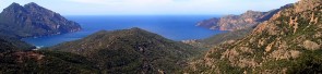
We are here on the summit ridge of the Sori valley, as well as in the middle of this spectacular ring itinerary. You go up until 700 meters away, at a panoramic parking lot, where you leave the road. Instead, you take a path that goes up towards the Monte dell'Uncellato, which at an altitude of 828 represents the highest peak of the route. Panorama over the entire Sori valley, of which we are doing the whole round!
It is touched by Monte Possuolo and from here a downhill path on a spectacular ridge goes to Cian by Cola and Mount Castelletti (on which you can walk around the coast, without getting up). We are here about 11 km from the start from Sori, but just 6 km practically all downhill from arrival to Sori itself. In fact, we find ourselves on the western side of the valley of Sori and, of course, from here onwards, for those who divide the excursion over several days, this part of the walk can be left to another trip. Going down to Monte Santa Croce: Right Bogliasco, on the left the valley of Sori
Monte Santa Croce, at an altitude of 518 meters, is a classic destination for sori trips. It is highly overview and reachable with a comfortable path from Cian da Cola and with an even more comfortable path from Sori itself. Al Monte Santa Croce there are some picnic tables and a small church, but the most beautiful thing is the maritime pines near the top. Panorama from Monte Santa Croce towards Genoa Panorama from Monte Santa Croce at the beginning of the drop-down path towards Sori
From Monte Santa Croce in about an hour and a quarter goes down to Sori, thus concluding this spectacular ring path. Alternatively, he got to connect to the paths for Pieve Ligure and from Pieve Ligure again coming down to Sori or in Bogliasco, as always described in this regard of the trek by Recco, Sori, Bogliasco and Nervi . The hills behind Sori, on which we have traveled the ring itinerary
This map indicates the itinerary:
This Google Maps map can help locate the path :) by clicking on all the Liguria maps The ring path of the valley of Sori is part of the paths of the Ligurian Riviera di Levante all described to this Page on the trek in Liguria . If you like outdoor activities and adventurous trips or if you want to find more photos of this and other destinations, as well as advice and new routes, visit our FB page and put it like:
or, excite yourself for Italian beauties from a sailboat. Italy in Vela - Photos and travel itineraries from North to South, 800 miles of navigation between spectacular islands, picturesque towns and memorable wines


.JPG)

.JPG)
.JPG)
.JPG)