La Guida Turistica del Pianeta Terra: un'esilarante avventura dalla Namibia alla Liguria!

La Guida Turistica del Pianeta Terra: un'esilarante avventura dalla Namibia alla Liguria!
La Guida Turistica del Pianeta Terra: un'esilarante avventura dalla Namibia alla Liguria!


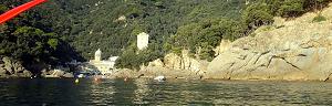
We have already described Bonassola through two splendid itineraries on the sea, those who connect it with Framura and Levanto on the paths or with the Cyclopedonal in the old train galleries . Instead, the path to Monte Rossola rises between the hills behind Bonassola, all over the sea but providing spectacular views of the coast, as well as on the hinterland to the Apuan Alps.

Going up on the roads behind Bonassola, towards the village of San Giorgio, you have suffered beautiful views of the sea.


An abandoned the road to a bend when a dirt road starts towards the collar step and Monte Rossola. It is immersed in an increasingly hilly nature, admiring the green around and for a short stretch almost forgetting about the sea (this hiking itinerary allows you to immerse yourself in the double nature of Liguria, close between sea and mountains).


Wanting to make a ring path, the descent takes place on the side towards the sea of Monte Rossola, after going up on the slopes side hinterland. Here the path is less comfortable and steeper, but fascinating with beautiful views. Just parties along the descent, you also notice the beautiful ridge of Monte Rossola and in the distance the peaks of the Apuan Alps.


Good trips!
If you like activities to Open air and adventurous trips or if you want to find more photos of this and other destinations, as well as advice and new itineraries, visit our FB page and put like:
Share this page with your friends:

Have you put it on our FB page?
Click here For an overview of the trekking in Italy
.JPG)
You will also find the links to the descriptions of several interesting hiking itineraries in Liguria, for example A sestri levante or trekking between The five lands and Portovenere .
Here is another fantastic way to see Liguria:
Liguria in KAYAK - Photos and Itineraries
click here instead for the page specifically dedicated to trekking in Liguria

or, excite yourself for Italian beauties from a sailboat.
.JPG)
Italy in Vela - Photos and travel itineraries
from North to South, 800 miles of navigation between spectacular islands, picturesque towns and memorable wines
some trekking theme travel diary, full of ideas and photos:
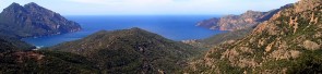
Corsica - Photos and travel itinerary
a wild island at your fingertips, ideal for hiking itineraries, with crystal clear sea and steep mountains
.JPG)
Iceland
.JPG)
Crete - Photos and travel routes
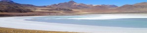
Chile and Patagonia Argentina
we go away, in authentic hiking paradises, with itineraries from deserts to glaciers
Discover Here The tourist guide of the Planet Earth , the richest, exciting and ironic guide on the whole world.
contact info@wildrips.net Click on a route, suggestions on a travel diary, collaborations or to organize trips at sea in Liguria.
Site map - Privacy