La Guida Turistica del Pianeta Terra: un'esilarante avventura dalla Namibia alla Liguria!

La Guida Turistica del Pianeta Terra: un'esilarante avventura dalla Namibia alla Liguria!
La Guida Turistica del Pianeta Terra: un'esilarante avventura dalla Namibia alla Liguria!


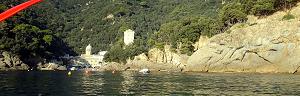
From the center of Sestri Levante Part The hiking itinerary for the promontory of Punta Manara , from which you can also descend for a steep path to the rocks of the ciappa du Lu to dive into the ligurian sea , here really crystalline. A very recommended walk in all seasons, in summer to go for a bath where the water is more blue, in winter to admire splendid views without sweating on the climb. The departure from the center of Sestri Levante, a stone's throw from the Baia del Silenzio , is truly characteristic ... and within 300 meters there are 28 bakers that produce delicious focaccia for the picnic. In short, this is the beginning of the most scocacciaoso path to the world .


The trek at a certain point becomes slightly more challenging for the rocky bottom of the path, which is not difficult but quite steep; There are still some benches that allow you to relax and enjoy the view.


From here you can continue towards the hamlet of Sestri Levante of the Ginestra (a quite panoramic path) and then trigose shore, or go back. We advise you to go down to the rock of Ciapa du Lu (wolf stone, in Genoese). Returning to Sestri, in fact, about 5 minutes from Punta Manara a path heads towards the sea.

This path is quite steep and slippery, even if well traced. Nothing impossible, but those who do not have a good balance is careful: do not kill yourself, in short (which is a bit of a lifetime). The effort (descends from the 150 meters high of peak manara to the sea, and then you will have to go up) is rewarded by the crystal clear waters around the Ciapipe du Lu.


If you like outdoor activities and adventurous trips or if you want to find more photos of this and other destinations, as well as advice and new itineraries, Visit our FB page and put it like:

Share this page with your friends:

Have you put it on our FB page?
Click here For an overview of the trekking in Italy
.JPG)
You will also find links to the descriptions of several interesting hiking itineraries, for example a portofino or trekking between Corniglia and reomaggiore Via flystra and manarola or again the one from Framura a levanto via bonassola or the even less beaten itinerary on the ligurian mar From Campiglia in Scala and cantons .
Here's another fantastic way to see Liguria:
Liguria in KAYAK - Photos and Itineraries
click here instead for the page specifically dedicated to trekking in Liguria

or, excite yourself for Italian beauties from a sailboat.
.JPG)
Italy in Vela - Photos and travel itineraries
from North to South, 800 miles of navigation between spectacular islands, picturesque towns and memorable wines
some trekking theme travel diary, full of ideas and photos:
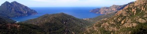
Corsica - Photos and travel itinerary
a wild island at your fingertips, ideal for hiking itineraries, with crystal clear sea and steep mountains
.JPG)
Iceland
.JPG)
Crete - Photos and travel routes
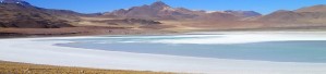
Chile and Patagonia Argentina
we go away, in authentic hiking paradises, with itineraries from deserts to glaciers
Discover Here The tourist guide of the Planet Earth , the richest, exciting and ironic guide on the whole world.
contact info@wildrips.net Click on a route, suggestions on a travel diary, collaborations or to organize trips at sea in Liguria.
Site map - Privacy