Travel itineraries, hiking, kayaking and sailing in Italy and in the world
At the mouth of the Gulf of La Spezia, the island of Palmaria Sweata imperious, in a panoramic position in front of Portovenere. The paths of Palmaria, and in particular the tour of the island, allow us to admire its wild vegetation, the ruins of military fortifications, the awesome cliffs and the clear Ligurian Sea. Portovenere View from the Palmaria Island
First of all, to get to Palmaria you have to take a boat (or your own nautical). From Portovenere there is a race every half hour (the distance is a few hundred meters, and the cost is 5 euros a/r), but in summer it is also possible to leave from the port of La Spezia (in winter , you need to inform yourself in advance about times, because they are reduced). Generally, you will arrive at terrible, right in front of Portovenere, where there is also a seaside settlement. From terrible, overcoming dry tip, you can start following the tour of the Palmaria (in my anticlockwise) walking along the coast, to the west. Among the dishes, you can bathe in the very clear water of the Ligurian Sea. The beginning of the path for the Giro della Palmaria Arrived in front of the church of San Pietro di Portovenere, the path starts to rise. This is the most difficult stretch of the itinerary, nothing too complicated, but not to be addressed in flip-flops! The vegetation is wild and the path is not preserved especially well. Looking back as you go up, however, the views repay fatigue. Going towards the summit of Palmaria, you leave behind beautiful views of Portovenere
In this part of the itinerary you walk on the side of the palmaria exposed to the open sea, a high coast with imposing cliffs, following the indications for the summit and then for the puddle. Sometimes, the panoramic points allow you to admire the grandeur of these rocky walls, around which the seagulls fly and the goats are ventured. The cliffs of Palmaria
Despite the splendid places and the presence of some bathing establishments, particularly in the stretch of coast towards Portovenere, Palmaria has a wild and neglected appearance. This is also due to its military past: characteristic ruins of buildings are scattered around the island, now submerged by the vegetation, and a few structures are still operational, including that of the traffic light battery, at the highest point that meet along the path . Antiaesthetic light poles follow the path and sometimes ruin the view in this first section of the itinerary. Going down from the traffic light drums, you can admire Cala Grande and Caletta, two inlets in the cliffs
When the traffic lights starts to go down, you can admire the cliffs around Cala Grande and Caletta and, in the background, the island of the tino. Above the cove, you can notice the ruins of old buildings and artificial holes in the rock, reachable by briefly reaching from the itinerary. The creek of the cove, as well as impressive, is inhabited by Millemila Seagulls, of which we have also seen eggs. The cliffs of the cove and, in the background, the path that descends from the traffic light battery
The path arrives at Cala del Pozzale, where you can make a refreshing dip. Here too there are old abandoned buildings, which give an idea of transference but that are purely. You can also walk up to the tip of the island, to get right in front of the tino. Puddle crockets
Above the puzzle, there are rocky walls and among these opens an inexplicable and gigantic square hole in the rock, another strangeness of the surprising palmaria.
Passing on a steep stretch and with the vague risk of being hit by a stone or a gull poop, we immediately went to see it. The artificial cave passes the mountain from and part and allows you to admire beautiful views (and inside there is also a chasm that comes straight to the sea). A square cave crosses a rocky wall over the puddle, another path of the path that goes around the palmaria
Leaving the puzzle, you proceed to Punta Marinella. A part of the beach is reserved for use of the military (anachronistic concept that I hope will soon disappear from the palmaria), while the path rises passing high along the coast. The views are sublime, both behind him, towards the tino, who in front of him, towards the coast of Tellaro and Montemarcello on the other side of the Gulf of La Spezia. View from the path on the tino and on the opposite bank of the Gulf of La Spezia
Arrived above Punta Marinella, he met a house; From here, a path, only apparently closed by a gate, leads to a beautiful beach where to bathe, the most insulated and deserted among those within walking distance (but, on summer weekends, the sea front is often full of boats). Continuing on the top, instead, you get immediately after admiring the Fornace Cala. Cala della Fornace, full of boat in a summer weekend
Among the most beautiful features of Palmaria is that, scattered around the island, there are curious military remains, of which it is difficult to understand how they were used. By entering ourselves for a disconnected path with the purpose of reaching another point on the sea of the Fornace Cala, we found ourselves to pass in an unexplained gallery in the middle of the woods. His lost position and danger collapses had made it the house of numerous seagulls.
A strange Palmaria Dulla Galleria
Returning to the main path, we continued up to the great Fortress Umberto Primo, then arrive at the sea on the side of the island towards the inside of the Gulf of La Spezia. Here are some bathing establishments (generally reserved for military and families), but also cultivations of mussels. View inwards the Gulf of La Spezia, with mussel cultivation in the foreground
The last traits of path (flat) and returns to the territory locality, from where you can resume a boat for the mainland. In all, the tour of the island is about 7 km for a total of 3 hours of walking, which often stretch with deviations, "curiosities" various and bathrooms.
Ah, a note about Portovenere: frequent buses connect it to La Spezia station, otherwise it can be reached by ferry (both from La Spezia and Riomaggiore). The car is also an option, but in high season get ready to park far away, spending 10 euros for a day (or more if you approach the center of the country). Apart from this ... Visit the Palmaria on the trails is a fantastic trip !! To be carried out preferably in May or September/October, when there is less confusion of bathers and boats, but you can still take a dip in the sea. This itinerary is one of the many trails between Genoa and Tuscany, all paths and All described to this Page on the trekking in Liguria .
This Google Maps map can help locate the path :) Click, go to the album with maps and photos To travel the entire west Riviera to the east, the previous stage is the incredible Riomaggiore Portovenere trail , while the next route leads to Lerici e TellaRaro .
If you like adventures in nature and wild trips, or if you want to find more photos of this and other destinations, as well as advice and new routes, visit ours FB page and put you like:
to admire Liguria from the canoe instead of walking: Liguria in kayak - Photos and travel routes an active exploration of Portofino, Cinque Terre and much more, aboard a canoe along the beautiful Ligurian coast
In particular, click here for the stretch Cinque Terre - Portovenere , who solcca the sea admired from the path.
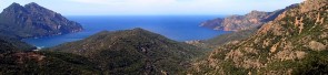
Other travel diaries and random itineraries : Corsica - Photos and travel itinerary a wild island at your fingertips, ideal for hiking itineraries, with crystal clear sea and steep mountains
Crete - Photos and travel routes windsurfing, off-road guide in the mountains, peaked paths on the sea: a wild approach a spectacular Greek island
Africa: photo and travel itinerary 8000 km through Namibia, Botswana, Zimbabwe and South Africa on a jeep with tents on the roof; A crazy journey on the road


.JPG)
.JPG)
.JPG)
.JPG)
.JPG)