Travel itineraries, hiking, kayaking and sailing in Italy and in the world
The trekking route between Deiva Marina and Framura allows you to admire the natural beauty of the Ligurian coast, but also the characteristic villages of coast, sect and anzo, generally overlooked by tourists and hikers. The colors of Liguria, with the green of the woods, the blue of the sea and the sky, and then flowers, fields and typical houses, go as a side dish to this comfortable but beautiful path. A stretch of the path above Framura
The departure of the route from Deiva Marina is located in the eastern part of the village, beyond the river, in correspondence with the "Camping Camping Camping Park" sign. Here, in reality, it is already common to Framura, Fornaci area. You take the road to the campsite, then follow the signs for Framura along the path that goes up in the woods, between bushes and majestic trees, with frequent beautiful views of the sea. In autumn, there is full of strawberries, the delicious red fruits typical of the Mediterranean scrub. The path that goes up from Deiva Marina
The itinerary at the beginning is steep, but there are no complicated steps. The path is easy to follow up to Casa Serro, where you arrive in half an hour. Here, at a junction, different possibilities open. We suggest to take the route, which soon becomes a comfortable dirt road, indicated with "Bonassola" and "Framura Setta/Costa Anzo Ravecca". The dirt road passes to a half coast, immersed in the vegetation but with continuous splendid views of the Ligurian Sea ranging from Punta Mesco to the promontory of Portofino ... and beyond, on clear days. The dirt road from Casa Serro to Framura
There is about 250 meters of altitude when a junction leads to the apicchi, a panoramic point reachable by a very short path. He then resumed the main dirt road and arriving at an asphalt road. Here, despite the inviting descent, I recommend following the climb, because thanks to this little effort you can walk the complete hiking itinerary, going to enjoy the most beautiful views of the trekking and to admire the magical borghetto of framura coast.
The paved road ends soon, at the Foce del Prato agriturismo, and the path continues in the woods, always well marked, up to the coast view. Coast of Framura view from the path
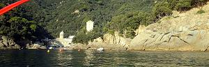
Remove the sea view here, which allows you to admire the other panoramic hamlets of Framura: sect and, lower, anz. Before descending to these villages through a wonderful path/staircase, you can take a ride to the tiny coast, admiring its medieval tower and the picturesque central alley. The ridge of Framura coast leading to the overview medieval tower
Those who want to stay in the area can search for the best accommodation here: As mentioned, from the coast a well-marked staircase goes to the sea. Although it costs is 300 meters away, it descends very quickly, passing between typical Ligurian houses and cultivated fields. The staircase that from the coast door to Setta, the main fraction of the Municipality of Framura
Setta is surrounded by greenery and has a medieval tower, tight alleys between the houses and panoramas always splendid. A corner of the sect, looking upwards and, in particular, towards the coast perched on the hill
We pass next to the houses of Ravecca and joins a paved path that cuts the hill into the coast. On the right, you go down to the beach of the Arena, while on the left you go to Anzo, which is worth admiring for the historic houses overlooking the path (do not use much use, the village is tiny!). At this point, you can resume the descent towards the long beach of the arena. The Arena beach
While the beach of the arena is stony, that, smaller, of the valley (separated by some rocks, on which you can easily walk) is sand and small bowls, and therefore more comfortable. Both beaches are connected to the framura station (and the beach of Torsei) through the new street of the sea. This short but beautiful walk also allows you to admire crystal clear water that laps the framursis rocks. A stretch of the seafront of Framura
In all, the path from Deiva Marina to Framura along this itinerary can take two and a half hours - three. From Framura station, you can go back by train to Deiva or continue with the next stage of the Liguria path. This Google Maps map can help locate the path :) by clicking on all the photos and maps In fact, this itinerary is one of the many paths between Genoa and Tuscany, all paths and all described to this Page on the trekking in Liguria . To travel the entire Riviera from West to East, the previous stage is that between Riva Trigoso, Moneglia and Deiva , while the next route is the Panoramic path for Bonassola and Levanto , or the fascinating Route in the old railway galleries that connect Framura, Bonassola and Levanto . Good trips !!! 1 ! 11 !!!! 1! 1! :)
If you like outdoor activities and adventurous trips or if you want to find more photos of this and other destinations, as well as advice and new itineraries, visit our FB page and put like:
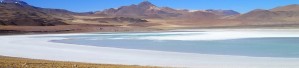
or, excite yourself for Italian beauties from a sailboat. Italy in Vela - Photos and travel itineraries from North to South, 800 miles of navigation between spectacular islands, picturesque towns and memorable wines
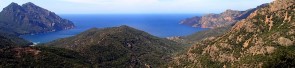
some trekking theme travel diary, full of ideas and photos: Corsica - Photos and travel itinerary a wild island at your fingertips, ideal for hiking itineraries, with crystal clear sea and steep mountains


.JPG)

.JPG)
.JPG)
.JPG)